Obabika River

Obabika River Provincial Park

2024 Operating Dates

Park / Campground Usage (day use, camping, etc.) - Legend Opening and Closing
Obabika River Backcountry Camping May 10, 2024 to October 27, 2024

Facilities

All Terrain Wheelchairs symbol Amphitheatres symbol Art Galleries symbol Backcountry Access Points symbol Boat Launch(es) symbol Campsites (Backcountry) symbol Campsites (Car Camping) symbol Campsites (Dog Free) symbol Campsites (Electrical) symbol Campsites (Group) symbol Campsites (Radio Free) symbol Campsites (RV Pullthrough) symbol Campsites (Seasonal Campsite Rental) symbol Campsites (Total) symbol Campsites (Walk In) symbol Comfort Station(s) symbol Docks symbol Dog Beaches symbol EV Charging Station symbol Fish Cleaning Buildings symbol Food Concessions symbol Group BBQ's symbol Historic Buildings symbol Laundromat symbol Museums (Logging etc.) symbol Park Store symbol Pet Exercise Area(s) symbol Picnic Shelters symbol Playground symbol Pools symbol Rentals - Bike symbol Rentals - Canoe symbol Rentals - Cross-country skis symbol Rentals - Ice Fishing Kit symbol Rentals - Ice Skates symbol Rentals - Kayak symbol Rentals - Motorboat symbol Rentals - Paddleboat symbol Rentals - Snowshoes symbol Rentals - Stand Up Paddleboard symbol Roofed Accommodation symbol Showers symbol Toilets (Interior Earth Pit) symbol Toilets (Vault Privies) symbol Trailer Dump / Fill Stations symbol Visitor Centre symbol Warm Up Shelters symbol Wifi (Public) symbol

Activities

Biking symbol Biking (Mountain Bike) symbol Boating symbol Boating - Motorboat Restrictions symbol Camping - Backcountry symbol Camping - Car symbol Camping - Dog Free symbol Camping - Group symbol Camping - Radio Free symbol Camping - Seasonal Campsite Rental symbol Camping - Walk In symbol Camping - Winter (including Roofed) symbol Canoeing symbol Dark Sky Viewing symbol Disc Golf symbol Discovery Program symbol Dogsledding symbol Fishing symbol Hiking symbol Hiking - Overnight Trails symbol Horseback Riding symbol Hunting symbol Ice Skating symbol Kite Boarding symbol Rock Climbing symbol Skiing - Cross Country symbol Snowmobiling symbol Snowshoeing symbol Swimming symbol Tobogganing symbol Whitewater Paddling symbol

Please note: Availability of some facilities and activities may be restricted to specific areas of the park, may be ecologically dependent, or may be seasonally weather dependent.

General Information

Regional Health Unit for this Park: Timiskaming Health Unit

Phone:

(705) 569-3205

Size: 20520.00 ha

Year established: 1989

Park Classification: Waterway

Address:

24 Finlayson Park Road
Temagami, ON
P0H 2H0


Social

What You'll Like:

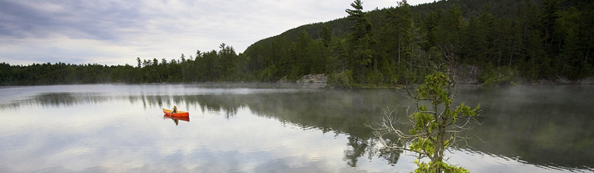
  • Obabika River contains an incredible diversity of landscapes, from island-speckled lakes to meandering rivers, bedrock uplands, expansive wetlands, as well as towering stands of old growth pine forests.
  • Remnants of the horse-logging days and old lumber camps can be found along many of the lakes in the park.
  • The Obabika Lake Old Growth Forest is one of the largest and oldest White Pine forests in Ontario. Trails take hikers through pristine stands of towering pine trees.
  • Temagami’s backcountry parks provide a remote wilderness experience, protect over 100,000ha, and provide roughly 600km of interconnected canoe routes.
  • Located in the heart of the Temagami region, Obabika River is connected to a 2400km canoeing network consisting of Parks, Conservation Reserves, and Crown lands.
  • The region’s canoe routes traverse some of the most rugged landscapes in Northern Ontario – 4 of the province’s highest peaks are in Temagami’s backcountry parks.
  • The area’s rich Indigenous heritage dates back at least 10,000 years, and canoeists travel on ancient portages or “nastawgan”.